Weather
After Storms: Much Cooler For The Weekend
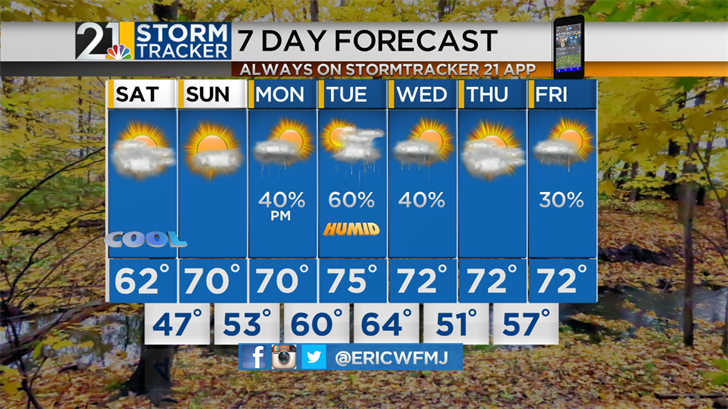
After producing a round of heavy, gusty thunderstorms, a powerful cold front will continue to push east of the area as the weekend gets underway. The final hours of summer will be quite cool and a dramatic change from Friday's high heat. Temperatures will be no higher than the lower 60s Saturday and readings will drop into the 40s overnight. The first full day of autumn looks like a winner. A good deal of sunshine will be accompanied by comfortable afternoon temperatures and lo...
Friday, September 21st 2018, 3:53 PM EDT
Updated:
After producing a round of heavy, gusty thunderstorms, a powerful cold front will continue to push east of the area as the weekend gets underway. The final hours of summer will be quite cool and a dramatic change from Friday's high heat. Temperatures will be no higher than the lower 60s Saturday and readings will drop into the 40s overnight.
The first full day of autumn looks like a winner. A good deal of sunshine will be accompanied by comfortable afternoon temperatures and low humidity.
The atmosphere is expected to moisten up again early in the new work week. Showers may arrive Monday afternoon but rain is most likely Tuesday into Wednesday morning. A few strong storms will be possible late Tuesday.