Weather 101: July's weather versus climatology
The first few days of August have started remarkably differently from the norm over July.
The second month of meteorological summer continued June’s warm trend, with July again checking in above average. However, while precipitation dove below average, hit-or-miss showers across the area caused certain locations to stray either above or below average.
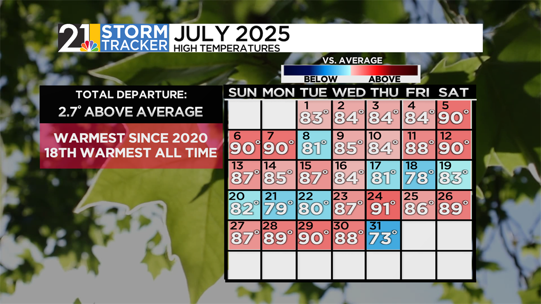
While dry, seasonable weather is the norm now in early August, only seven days featured a high temperature below average. The first day of July rode on the coattails of the Valley’s first heat wave, which occurred in late June. It started dry and fair, with the first work week of the month ending on a sunny, mild Independence Day. By the weekend, though, things began to heat up, and three straight days of 90°F allowed for the airport to go through the second heat wave of the season. In the first full week of the month, consistent “popcorn” rain showers and storms were beginning to take hold over the area, though the airport got away from most of these showers, only recording significant totals on July 7th. Halfway through the month, there had been all but one day with temperatures above average.

Additionally, it was humid as well. Dew points regularly got into the 70s during the daytime, setting the stage for a recurring theme of hot and humid weather and showers. Cooler air moved through the area after July 17th. July 18th’s high of 78°F was the first sub-80°F day since mid-June, breaking a top-ten streak. After another warmup later on in the month, and the Valley’s subsequent fifth- and sixth-90°F days of the season, a cold front moved through by the end of the month and significantly dropped temperatures. July 31st’s high of 73°F was the coldest for the entire month.
Officially, the airport’s average temperature throughout the month was recorded at 74.2°F. This takes into account the observed high and low temperatures each day. This is 2.7°F above the average June temperature of 71.5°F. While notably higher than average, the month wasn’t historically warm; it is the 18th warmest July of all time and is the warmest in five years.
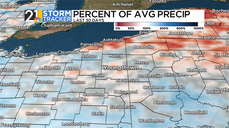
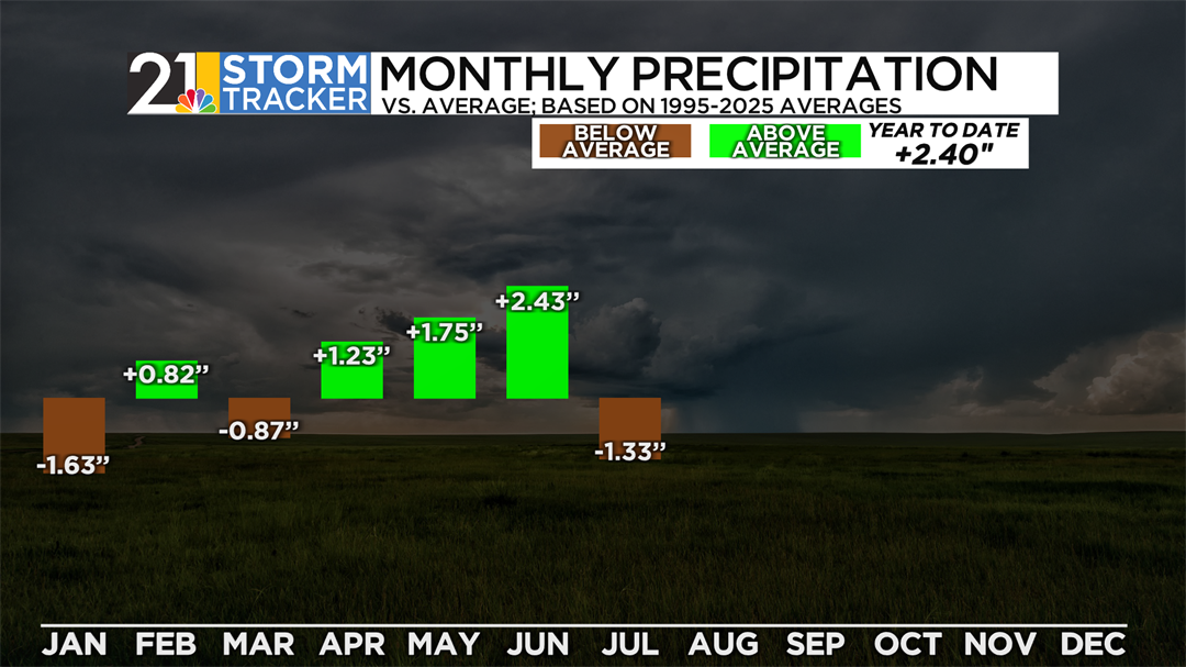
While July is the wettest month climatologically, the airport finished the month below average in terms of precipitation. The monthly observation of 2.94” is about two-thirds of the typical monthly rainfall of 4.27”. However, thanks to rain being more “bubble-up” than organized, there were significant differences in accumulation locally. Those in northern Trumbull and eastern Mercer & Lawrence counties saw above-average rainfall, but those close to metro Youngstown and Columbiana county did not experience as much.
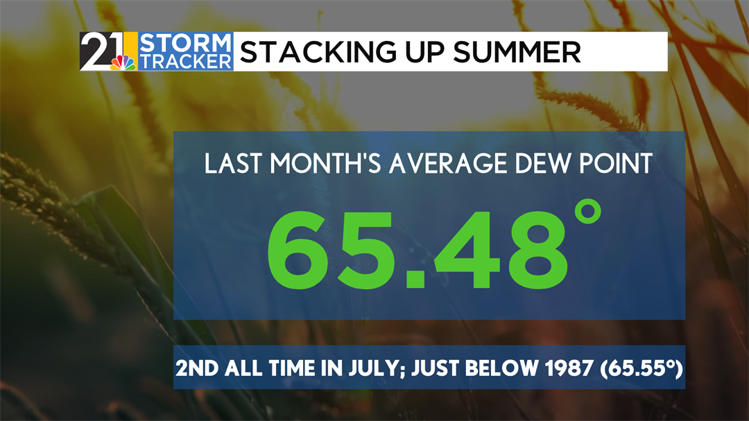
Dew point, an essential variable in the warm months of the year, determines the amount of moisture content in the atmosphere. It is a major indicator of how comfortable people feel in hot weather. July’s average dew point of 65.48°F barely marks it below the month’s high in 1987 (65.55°F), but on the coattails of June’s record humid month, the summer has far and away been the most humid season on record- dating back to the 1940s.
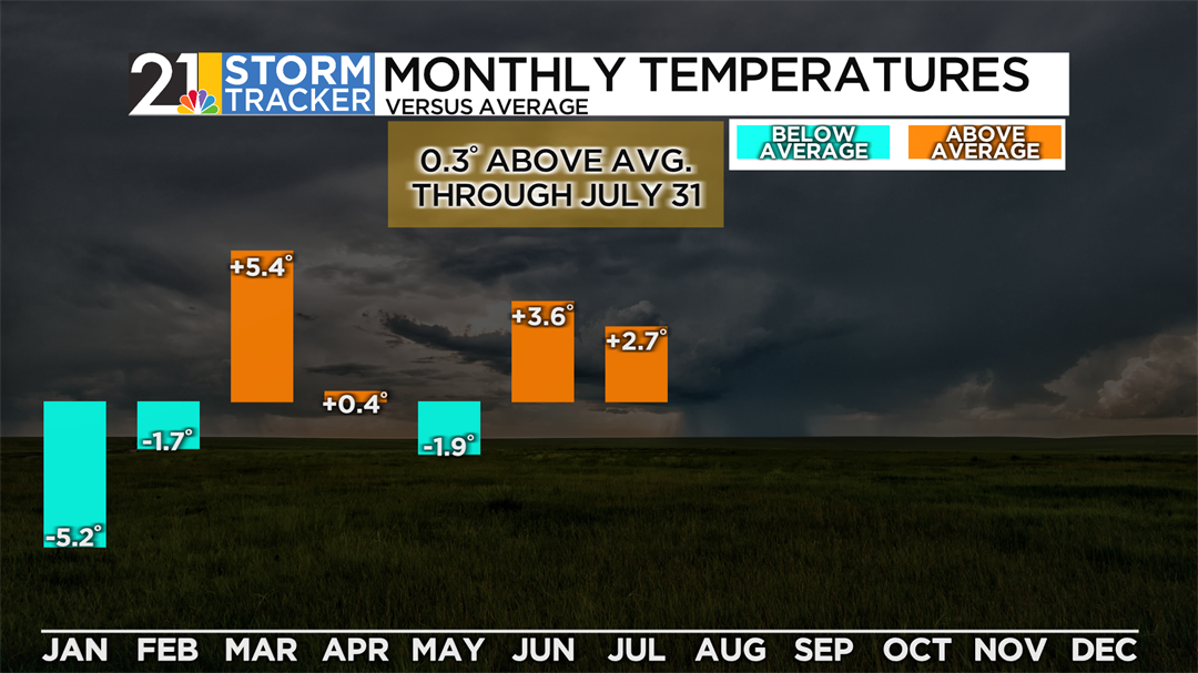
How does this impact Youngstown’s yearly weather trends? Now that over half of the year is complete, we can begin to discern how 2025 will play out compared to climatology. Thanks to a very chilly and dry winter, the summer’s wet and warm months have offset the year’s initial chill. To date, the year is 0.3°F above its all-time average, though still the coldest start to a calendar year since 2015. While spring and early summer brought lots of rain to the airport, July was able to take the surplus down to a manageable amount- just about two and a half inches of rain above average. The airport has taken in 26.80” of rain this year, with the average just around 24 1⁄2 inches.