
A windy and damp end to the week
An active yet mild pattern will lead us out of the first full week of 2026, but colder air is on the way next week.
Thursday remains calm with temperatures peaking in the low 50s in the afternoon. Temperatures will only fall to the mid-40s before midnight, then rise overnight.
An area of low pressure will usher in active, mild, and windy weather on Friday.
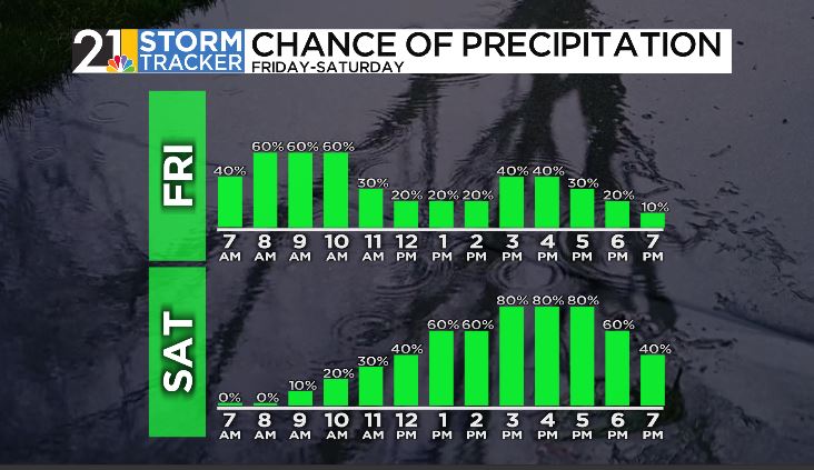
A shower or two is possible around midnight, but better chances for rain come during the morning hours on Friday. Showers could become widespread briefly on Friday morning, then transition to scattered showers on Friday afternoon, eventually tapering off completely just after sunset. A warm front will lift over the region, ushering in mild air with high temperatures in the low 60s on Friday afternoon.
Winds will increase from Thursday night into Friday with gusts up to 40 mph at times.
A cold front will cross over the region on Thursday evening, but quiet weather won't last long as a second area of low pressure will build in on Saturday.
Showers will hold off for most of the morning on Saturday, then become widespread again Saturday afternoon; high temperatures will remain warmer than average in the upper 40s. Showers will then turn to flurries and light snow showers as a burst of cold air invades the area Sunday morning.
Sunday will be breezy and much colder with high temperatures in the low 30s. Scattered light snow showers will be around throughout the day.
Next week won't feature harsh cold by any means, but temperatures will be closer to the average, especially during the second half of the week.
